Monitoring Alaska's volcanoes for 25 years
April 02, 2013
On April 1, the Alaska Volcano Observatory, a cooperative program of the U.S. Geological Survey, the University of Alaska Fairbanks Geophysical Institute, and the Alaska Division of Geological and Geophysical Surveys, marked its 25th anniversary.
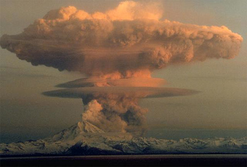
Ascending eruption cloud from Redoubt Volcano as viewed to the west from the Kenai Peninsula on April 21, 1990. The mushroom-shaped plume rose from avalanches of hot debris (pyroclastic flows) that cascaded down the north flank of the volcano. A smaller, white steam plume rises from the summit crater.
The primary volcano hazard in Alaska is airborne ash that endangers aircraft flying the busy North Pacific air routes connecting North America and Asia. The hazard played out dramatically on December 15, 1989 when a wide-body passenger jet encountered an ash cloud from Redoubt Volcano and lost power in all four engines over the Talkeetna Mountains. Fortunately, after more than 4 harrowing minutes of descent, engines were restarted and the plane landed safely in Anchorage. This near-tragedy prompted renewed international efforts to more effectively address the hazards of airborne volcanic ash. In addition to endangering aircraft, volcanoes near population centers can pose significant hazards to infrastructure and communities from ash fall, lahars, and other rapidly flowing mixtures of hot rock fragments, fluids, and gases. AVO has developed a far-reaching volcano monitoring program in Alaska and partnered with federal, state and municipal agencies, to improve warnings of volcanic eruptions. AVO led the development of the standard Aviation Color Code to communicate hazards in a simple, consistent manner; this warning system is now endorsed by the International Civil Aviation Organization for use by volcano observatories worldwide. AVO pioneered cooperative programs with volcanologists in the Russian Far East, also home to dozens of explosive volcanoes that threaten aircraft, to create a system to warn the aviation industry of eruptions in Kamchatka and the Kuriles. Over 25 years, AVO expanded from an early focus on just Cook Inlet volcanoes to a current monitoring and research program that includes daily observations of all 52 historically active volcanoes in Alaska. To address the aviation hazard, AVO expanded ground-based monitoring networks from Cook Inlet to volcanoes on the Alaska Peninsula and Aleutian Islands. Throughout the years, AVO and its colleagues developed innovative ways to track earthquake activity, ground deformation, and volcanic gas output, and analyze satellite imagery in the harsh Alaskan environment. Geologic studies of volcanoes and eruptions by AVO scientists provide insights into eruptive histories, information needed to assess future hazards and inform planning efforts. AVO issues daily and weekly updates of volcanic activity in Alaska. The most recent information along with a wide range of volcano information, real-time data, and images is available on the AVO website. Volcanic activity notices are also served through Twitter @alaska_avo.
Source of News:
E-mail your news &
photos to editor@sitnews.us
|
||
