Alaska Science Carpeting the Denali Fault with earthquake sensorsBy NED ROZELL
April 23, 2016
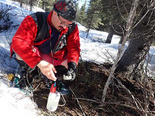
"Starting operation," says a tinny voice that sounds like a woman from London. The words come from a thick tablet attached to the cable. In less than 10 minutes, Allam has deployed another shake-detection instrument on one of Alaska's greatest earthquake producers, the Denali Fault.
Amir Allam of the University of Utah and UAF installs a temporary seismometer near the Denali Fault between Delta Junction and Glennallen.
A team of five including seismologist Carl Tape of the Geophysical Institute installed almost 200 of the instruments during three sunny days in mid-April. They favored shoving the seismometers into ground at the base of spruce trees, where there was less snow to shovel and ample soil to receive the spikes. The fading snowpack was still about four feet deep. Cold nighttime temperatures formed a crust that could support the scientists' weight until early afternoon. "Conditions are pretty good right now," Lock said at noon, "But once everything starts melting they're the worst." "We've sunk in chest deep," says Allam, who, like Lock, is big as a bear.
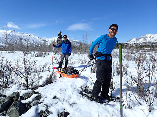
From left, graduate students Yadong Wang (University of Utah) and Kyle Smith (UAF), haul gear for installing temporary seismometers on the Denali Fault south of Delta Junction.
Lin said yes. Carl Tape had the local connections to shelter the science team in a log cabin belonging to a friend. The plan was on. Allam and Tape will leave the seismometers in place for one month. They'll return in May to pick them up in a season with less snow and more mosquitoes. In those 30 days, the instruments will record hundreds of earthquakes. The data from the dense network should give seismologists a better idea of the Denali Fault's character. They already know huge earthquakes happen on the fault. A rupture there caused a magnitude 7.9 earthquake on November 3, 2002, tearing a 200-mile line across the face of Alaska, through soil and glacial ice. The fault is an ancient trench through central Alaska maintained by Earth's crustal forces shoving in opposite directions. Framed by the mountains of the Alaska Range, the Denali Fault is easy to spot on a map. "It's a big frowny face in the middle of Alaska," Allam said. The scientists want to see what the fault looks like beneath the surface. They hope to define the damage zone, a band of rocks broken by past earthquakes. There, energy waves can be trapped during an earthquake, intensifying the shaking. While Allam and Lock blanketed part of where the fault ripped the surface during the 2002 earthquake, Tape and graduate students Kyle Smith and Yadong Wang worked closer to Canwell Glacier, which lies in a valley maintained by the Denali Fault. In brilliant sunshine, they snowshoed over piles of gravel shoved by the glacier. They stopped at spruce trees, placing their instruments beneath them. Dozens of seismometers now rest quietly in forest and near glacier in the middle of Alaska, waiting for the ground to speak.
Since the late 1970s, the University of Alaska Fairbanks’ Geophysical Institute has provided this column free in cooperation with the UAF research community.
Representations of fact and opinions in comments posted below are solely those of the individual posters and do not represent the opinions of Sitnews.
|
||

