Statendam Assists 103 Sightseers And Ranger In Glacier Bay
August 05, 2013
Monday
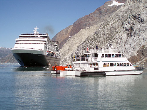
(SitNews) - While leaving from Margerie Glacier to depart Glacier Bay, Alaska, Holland America Line's ms Statendam assisted 103 persons on a disabled sightseeing boat Friday, Aug. 2.
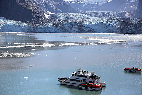
Statendam responded to a call for aid at approximately 1:45 p.m. local time to stand by to possibly assist the 79-foot sightseeing vessel Baranof Wind, which was experiencing mechanical troubles and had lost power in the ice near John Hopkins Glacier.

Holland America Line’s ms Statendam assisted 103 persons on the disabled 79-foot sightseeing vessel Baranof Wind
Photo Credit: Dirk van Aarsen ©2013, Holland America Line
The ship lowered two tenders, which collected 102 tourists and one Glacier Bay National Park ranger and returned to Statendam. A Glacier Bay National Park ranger aboard Statendam assisted in coordinating the assistance from the ship's bridge.
The sightseers were brought to Bartlett Cove, where the Baranof Wind's excursion originated, at approximately 7:30 p.m. local time. The ship then sailed for Seward, Alaska, where it was expected to arrive on schedule Sunday.
"Statendam's Captain Jochem Bakker and his crew responded quickly and professionally to assist the passengers of Baranof Wind," said Richard Meadows, executive vice president marketing, sales and guest programs for Holland America Line. "We are proud of our officers and crew."

Statendam Assistance Glacier Bay
Photo Credit: Bert van Mackelenbergh ©2013, Holland America Line
Glacier Bay Basin is located in southeastern Alaska. Located at the deep end of Glacier Bay, Margerie Glacier is a 21 miles-long tide water glacier that begins on the south slope of Mount Root, at the Alaska-Canada border in the Fairweather Range, and flows southeast and northeast to Tarr Inlet, one mile north of the terminus of Grand Pacific Glacier and 87 miles northwest of Hoonah, Alaska.
The steep dropoff of the Margerie Glacier cliff facilitates large cruise ships to park close to the glacier from where one gets incredible views of the glacier.
The Johns Hopkins Glacier rises from the Fairweather Range on the east slopes of Lituya Mountain and Mount Salisbury and has a westerly flow towards the head of Johns Hopkins Inlet, 79 miles northwest of Hoonah.
The Johns Hopkins Glacier cannot be approached any nearer than about 2 miles by sea because of the volume of the ice blocks that break loose from its cliffs.
Edited by Mary Kauffman, SitNews
Source of News & Photograph:
Holland America Line
www.hollandamerica.com
E-mail your news &
photos to editor@sitnews.us
Publish A Letter in SitNews
Contact the Editor
SitNews ©2013
Stories In The News
Ketchikan, Alaska
|
Articles &
photographs that appear in SitNews may be protected by copyright
and may not be reprinted without written permission from and
payment of any required fees to the proper sources.
|
|


