Technology aids recovery of 1952 Alaska plane wreck
August 11, 2015
In June, the Scripps Institution of Oceanography, U.S. Air Force, Alaska Army National Guard and Defense POW/MIA Accounting Agency used a portable weather station (the Expeditionary Meteorology System, or XMET), developed with support from the Office of Naval Research (ONR), to monitor conditions at a 1952 crash site of a military transport aircraft.
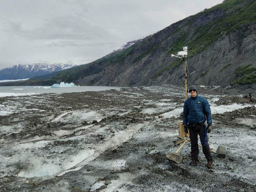
Air Force Staff Sgt. Stephen Soloff stands next to the XMET system used at the Colony Glacier plane crash site in Alaska.
Transported in a hard-shell case, the XMET is mounted on a tripod and can be assembled in five minutes by two people with no tools. The solar battery-powered system uses sensors to compile real-time measurements of rain, wind, temperature and visibility--relaying hourly weather information via satellite to planners who can use the data to cancel or proceed with a mission. Previously, such detailed information could only come from observers on the ground. "The XMET was extremely useful in the crash site's environment," said Scott Katz, a special projects officer at Scripps. "The surface of the glacier can only be accessed by helicopter. The XMET provided valuable meteorological measurements to let recovery crews know if it was safe to fly each day, allowing them to make informed predictions and keep everyone out of harm's way." The XMET resulted from a 2008 conversation between a Marine and Scripps researchers about the need for better weather-forecasting technology because of the dangers of flying in extreme desert conditions. The researchers reached out to ONR for support and, within a year, the XMET emerged and was soon being used by warfighters in Iraq and Afghanistan. This year's recovery efforts in Alaska, which wrapped up in July, marked the first time the XMET was used at the Colony Glacier site. Six decades ago, an Air Force C-124 Globemaster II crashed into Mount Gannett in the jagged Chugach Mountains -- known as Alaska's "graveyard of airplanes." Mount Gannett is a 9,649-foot peak in the Chugach Mountains of eastern Alaska, located 50 miles east of Anchorage. The 1952 Mount Gannett crash was an accident in which a United States Air Force Douglas C-124 Globemaster II military transport aircraft crashed into Mount Gannett in the Chugach Mountains on November 22, 1952. All of the 52 people on board were killed. The C-124 departed McChord Air Base in Washington state en route to Elmendorf Air Force Base near Anchorage with a crew of 11 and 41 Army and Air Force passengers. A search party was dispatched, but harsh weather turned them back, entombing the wreckage in snow and ice. Apparently, the 1952 crash had also triggered avalanches that had further buried the remains. Because of the difficult conditions, the recovery effort was terminated after a week and the victims' families were told they would have no remains to bury.The debris was then covered by snow and ice, and was lost for the next 60 years. On June 28, 2012, the U.S. military announced the discovery of the wreckage. The recovery operation was then taken over by the Joint POW/MIA Accounting Command, whose primary role is to search for US military personnel missing overseas. On June 18, 2014, after two seasons of operations on the glacier, the Department of Defense announced that the remains of 17 of the victims had been identified and would be returned to their families for burial. In 2012, a plane spotted yellow debris on the slowly melting glacier, situated at the base of Mount Gannett. The Alaska Army National Guard investigated and identified the C-124. Since then, month-long recovery efforts have been held each summer to retrieve debris and identify remains of the 52 crew members and passengers. So far, 17 people have been identified and returned to their families for burial. There is a race against the clock to recover as many remains as possible before the wreck site breaks off Colony Glacier and sinks into a nearby lake. In addition to the Alaska recovery efforts, XMET technology is being used in places like the Republic of Palau to monitor weather conditions at World War II aircraft crash sites, and in the Philippines to help forecast typhoons and other storms. The XMET aligns with several tenets of the Cooperative Strategy for 21st Century Seapower, a maritime strategy shared by the U.S. Navy, Marine Corps and Coast Guard. The strategy calls for increased focus on battlespace awareness, which includes surveillance, intelligence gathering and greater knowledge about the environments in which warfighters operate.
Edited by Mary Kauffman, SitNews
Source of News:
|
||
