Wetter than normal August in Southeast
September 20, 2017
According to the National Weather Service Forecast Office, some record highs were set as well during the first week of August with temperatures rising to 80 degrees or above.
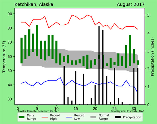
In total, at least 16 locations in southeast saw daytime highs during the first week of August of 80 degrees or higher. Topping out the list of sites experiencing truly hot temperatures was Skagway, which recorded 93 degrees for the daytime high on August 5th. Ketchikan's highest temperature for the month was also on August 05th with 86 degrees recorded, but not record breaking. Ketchikan's record high was 90 degrees set on August 08, 1960. The record low was set on August 31, 1973 at 40 degrees. Ketchikan's lowest temperature for the month was 51 degrees on August 19, 2017. Summer warmth and dry weather was replaced with overly wet conditions by the middle of August. Soon thereafter, nearly all locations had met or exceeded their normal monthly precipitation totals. The exception was, once again, the northeast gulf coast. Yakutat did end the month with above normal precipitation, but that did not occur until the last week of the month. Multiple daily rainfall records were set in southeast. Ketchikan International Airport was particularly notable with a three day total of over 9 inches and a one day total of 4.18 inches on August 22nd. This smashed a 100 year old record of 2.27 set back in 1917 and coincided with an atmospheric river event that affected the entire panhandle. Ketchikan also had the dubious distinction of experiencing the rainiest summer on record with a 3-month total of 46.99 inches of rain. Ketchikan's record precipitation for August was set in 1958 at 20.72 inches and the lowest precipitation on record was 0.62 inches in 1945.
Reporting and Editing by Mary Kauffman, SitNews
Source of News:
Representations of fact and opinions in comments posted are solely those of the individual posters and do not represent the opinions of Sitnews.
|
|||
