Landmark report on active faults and seismic hazards in Alaska released
September 26, 2018
This newly released report by the Division of Geological & Geophysical Surveys and Alaska Seismic Hazards Safety Commission summarizes the current state of knowledge of active faults throughout Alaska. This is the first report of its kind for Alaska. It was spearheaded by the Alaska Seismic Hazards Safety Commission, which recognized the growing need for a comprehensive, one-stop information resource summarizing the known sources of seismic hazards in Alaska. Alaska is the most seismically active region of the United States and large damaging earthquakes pose significant risks to the state’s infrastructure and inhabitants according to the report. Despite the hazards associated with high rates of tectonic activity, geologic information on the relative activity of young faults in Alaska is sparse. “This report will provide guidance for future earthquake research in Alaska, serve as a resource for seismic hazard studies, and complement the Alaska Quaternary fault database,” said lead author Richard Koehler, earthquake science professor at the University of Nevada and former earthquake hazards manager for the division.
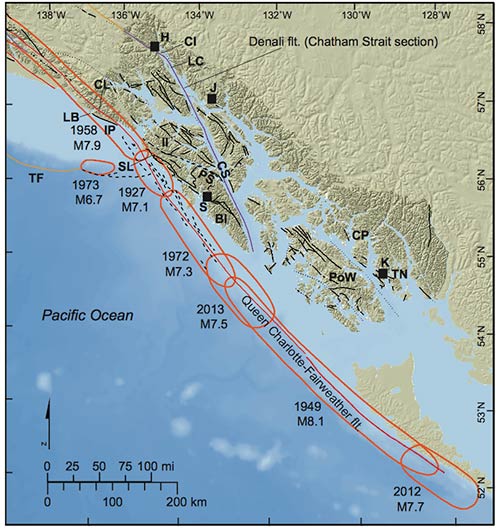
In Southeast Alaska, active seismic sources include the Fairweather–Queen Charlotte fault system, the Chatham Strait section of the Denali fault, the eastern end of the Transition fault, and other potentially active faults mapped in bedrock ( see graphic). The highly active right-lateral Fairweather–Queen Charlotte transform fault system marks the bound-ary between the Pacifc and North American plates and constitutes the locus of much of the region’s seismicity. Earthquakes are generally shallow crustal events along right-lateral strike-slip faults with more than 400 greater than or equal to 4.0 magnitude events and 20 strong earthquakes, greater than or equal to 6.0 magnitude, in the last 60 years (Alaska Earthquake Center, 2016). According to the report, the Fairweather–Queen Charlotte fault in Southeast Alaska has generated several major destructive earthquakes in the last century including the 1949 Moment Magnitude 8.1 earthquake on shore of the Queen Charlotte Islands, the 1958 Lituya Bay earthquake Moment Magnitude 7.9 on the northern part of the system, and the 1972 Moment Magnitude 7.3 earthquake west of Sitka. The Lituya Bay earthquake triggered a massive landslide into Lituya Bay that generated a 1,772-foot-high wave and the 1972 earthquake was felt to distances of nearly 620 miles. Two recent earthquakes in Southeast Alaska, the 2012 Moment Magnitude 7.7 Haida Gwaii earthquake along the southern extension of the fault in offshore British Columbia and the Moment Magnitude 7.5 earthquake near Craig on Prince of Wales Island, approximately 75 miles from Ketchikan, caused minor shaking damage and tsunami warnings. The 65-page report includes previously unpublished observations from many active faults visited during ongoing infrastructure studies by the Division of Geological & Geophysical Surveys. The Alaska Seismic Hazards Safety Commission is charged with advising decision-makers at all levels of state government and in the private sector about ways to reduce earthquake risks, and disseminating information on earthquake risk mitigation to the public. Although additional future studies of active faults are still needed to adequately address seismic hazards and risk in the state, the information presented in this newly released report contributes to the core charter of the Alaska Seismic Hazards Safety Commission by providing data that is said will ultimately lead to better hazard evaluations and mitigation practices.
On the Web:
Reporting and Editing by Mary Kauffman, SitNews
Source of News:
|
||||||

