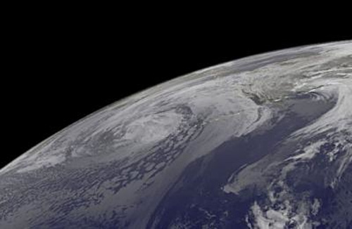
Extra-tropical Typhoon Wipha Affects Alaska
October 18, 2013
NOAA's GOES-West satellite captured this infrared image of extra-tropical storm Wipha affecting Alaska on Oct. 18 at 1200 UTC/8 a.m. EDT.
Typhoon Wipha was born of the twenty-fifth tropical depression in the northwestern Pacific Ocean. It developed far south of the Japanese Island of Iwo To, tracked northwest, then curved northeast passing and almost paralleling the coast of the big island of Japan while its center never made landfall. On Oct. 13 at 2113 UTC/5:13 p.m. EDT, NASA and the Japan Space Agency's Tropical Rainfall Measuring Mission or TRMM satellite flew over Wipha and measured rainfall rates. Heaviest rains were occurring to the north and northeast of the center of circulation, falling at a rate of greater than 1 inch per hour. By Oct. 14 at 0300 UTC, Wipha's maximum sustained winds reached an impressive 110 knots/126.6 mph/203.7 kph. At that time Wipha was centered near 22.2 north and 135.3 east, about 370 nautical miles west-southwest of Iwo To, Japan. Wipha was moving to the north-northwest at 13 knots/14.9 mph/24.0 kph and generating extremely rough seas up to 41 feet high. Wipha's center grazed Tokyo on Oct. 16 while remaining at sea and moving parallel to the Japanese east coast and swing into the northern Pacific. On Oct. 13, the Joint Typhoon Warning Center noted "animated multispectral satellite imagery depicts a large system with tight spiral banding wrapping into a low level circulation center with an eye that has contracted and become more ragged over the past six hours." Wipha's final warning was issued on Oct. 15 by the Joint Typhoon Warning Center. Wipha's maximum sustained winds were near 65 knots/74.8 mph/120.4 kph. At 2100 UTC/5:00 p.m. EDT Wipha's center was near 34.3 north and 140.4 east, about 161 nautical miles south-southwest of Yokosuka, Japan. It was moving northeastward at 30 knots/34.5 mph/55.5 kph at that time. Animated infrared satellite imagery showed the system continued to accelerate northward and had become more disorganized and elongated, especially along the northern edge. Then a tropical storm, Wipha continued moving northeastward ahead of a trough of low pressure where it began transitioning into an extra-tropical storm over cooler waters. Wipha crossed the Pacific Ocean and moved into the Bering Sea where it began lashing Alaska on Oct. 17 and 18 with strong winds, unseasonably warm temperatures and heavy rainfall. On Oct. 18, the National Weather Service noted that ex-typhoon Wipha moved into the Southern Bering Sea and will slowly fill as it arcs northeast to Nunivak Island on Saturday, Oct. 19 and then drift northwest and dissipate south of Saint Lawrence Island on Sunday, Oct. 20.
Source of News:
E-mail your news &
photos to editor@sitnews.us
|
||
